Victoria, British Columbia to Olympia, Washington
Distance: 231.7km (144.0 miles)
|
| 1. | Start out heading SOUTH on DOUGLAS STREET towards PANDORA AVENUE. Drive for 900 meters. |
| 2. | Turn RIGHT onto BELLEVILLE STREET. Drive for 600 meters. |
| 3. | Turn SLIGHT RIGHT onto an access street. Drive for 100 meters. |
| 4. | Keep SHARP RIGHT to stay on an access street. Drive for a short distance. |
| 5. | Take the VICTORIA-PORT ANGELES FERRY for 20.1 kilometers. |
| 6. | You are leaving Canada and entering the United States. |
| 7. | Go STRAIGHT on PORT ANGELES-VICTORIA BC FERRY. Drive for 16.4 kilometers. |
| 8. | Go STRAIGHT on N LAUREL STREET. Drive for 400 meters. |
| 9. | Turn LEFT onto E 1ST STREET. Drive for 3.6 kilometers. |
| 10. | E 1ST STREET becomes E US-101. Drive for 183.8 kilometers. |
| 11. | Take I-5 N towards OLYMPIA / SEATTLE. Drive for 1.8 kilometers. |
| 12. | Take exit number 105 towards PORT OF OLYMPIA / CITY CENTER / STATE CAPITOL. Drive for 100 meters. |
| 13. | Keep SLIGHT RIGHT at the fork towards ramp towards PORT OF OLYMPIA. Drive for 200 meters. |
| 14. | Go STRAIGHT on HENDERSON BOULEVARD SE. Drive for a short distance. |
| 15. | Keep SLIGHT RIGHT to stay on HENDERSON BOULEVARD SE. Drive for 200 meters. |
| 16. | Go STRAIGHT on E BAY DRIVE. Drive for 400 meters. |
| 17. | Keep SHARP LEFT to stay on E BAY DRIVE. Drive for 600 meters. |
| 18. | You have reached the stop-over. |
Olympia, Washington to West Yellowstone, Montana
Distance: 1279.7km (795.2 miles)
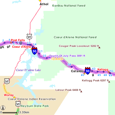
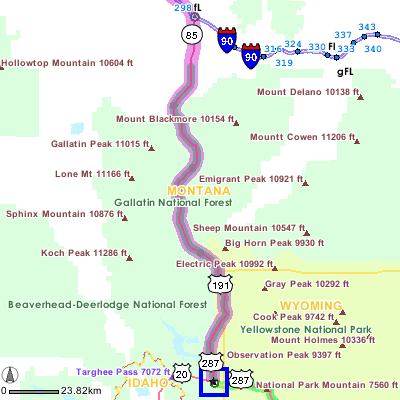
|
| 19. | Start out heading SOUTHEAST on PLUM STREET SE towards PEAR STREET SE. Drive for a short distance. |
| 20. | Go STRAIGHT on E BAY DRIVE. Drive for 200 meters. |
| 21. | Go STRAIGHT to get on I-5 N. Drive for 57.6 kilometers. |
| 22. | Take exit number 142A to get on WA-18 E towards AUBURN / NORTH BEND. Drive for 44.5 kilometers. |
| 23. | Take I-90 E towards SPOKANE. Drive for 1029 kilometers. |
| 24. | Take exit number 298 towards BELGRADE / MT-291 / W YELLOWSTONE / MT-85. Drive for 500 meters. |
| 25. | Turn LEFT onto AMSTERDAM ROAD. Drive for 1.3 kilometers. |
| 26. | Turn RIGHT to get on JACKRABBIT LANE heading SOUTH. Drive for 10.4 kilometers. |
| 27. | Go STRAIGHT on US-191. Drive for 130.7 kilometers. |
| 28. | Turn RIGHT onto FIREHOLE AVENUE. Drive for 100 meters. |
| 29. | You have reached the stop-over. |
West Yellowstone, Montana to Moab, Utah
Distance: 887.9km (551.7 miles)
|
| 30. | Start out heading WEST on FIREHOLE AVENUE towards DUNRAVEN STREET. Drive for 400 meters. |
| 31. | Go STRAIGHT on US-20. Drive for 170.2 kilometers. |
| 32. | Go STRAIGHT on GRANDVIEW DRIVE. Drive for 200 meters. |
| 33. | Turn RIGHT to get on I-15 S towards I-15 / US-20 / ARCO / POCATELLO. Drive for 224.4 kilometers. |
| 34. | Stay SLIGHT LEFT on I-15 S heading towards I-15 S / I-84 E / OGDEN / SALT LAKE. Drive for 194.8 kilometers. |
| 35. | Take exit number 261 to get on US-6 towards US-6 E / PRICE / US-89 E / MANTI. Drive for 204.6 kilometers. |
| 36. | Go STRAIGHT to get on I-70 E. Drive for 37.9 kilometers. |
| 37. | Take exit number 180 towards US-191 / MOAB. Drive for 600 meters. |
| 38. | Turn RIGHT to get on US-191 heading SOUTH. Drive for 50.7 kilometers. |
| 39. | Turn RIGHT onto W 200 S. Drive for 200 meters. |
| 40. | You have reached the stop-over. |
Moab, Utah to Aztec, New Mexico
Distance: 308.3km (191.6 miles)
|
| 41. | Start out heading EAST on W 200 S towards S 100 W. Drive for 200 meters. |
| 42. | Turn RIGHT onto S MAIN STREET. Drive for 1.3 kilometers. |
| 43. | Go STRAIGHT on S US-191. Drive for 84.8 kilometers. |
| 44. | Turn LEFT onto CENTRAL STREET. Drive for 1.7 kilometers. |
| 45. | CENTRAL STREET becomes US-491. Drive for 94.2 kilometers. |
| 46. | Turn SLIGHT LEFT onto PINON DRIVE S. Drive for 400 meters. |
| 47. | Go STRAIGHT on N LINDEN STREET. Drive for a short distance. |
| 48. | Turn LEFT onto W MAIN STREET. Drive for 300 meters. |
| 49. | W MAIN STREET becomes E MAIN STREET. Drive for 2.3 kilometers. |
| 50. | E MAIN STREET becomes US-160 E. Drive for 52.5 kilometers. |
| 51. | Turn RIGHT onto CO-140. Drive for 37.3 kilometers. |
| 52. | Go STRAIGHT on NM-170. Drive for 8 kilometers. |
| 53. | Turn LEFT onto NM-574. Drive for 22.3 kilometers. |
| 54. | Turn LEFT to get on US-550 N. Drive for 1.4 kilometers. |
| 55. | Go STRAIGHT to get on US-550 N. Drive for a short distance. |
| 56. | You have reached the stop-over. |
Aztec, New Mexico to Moab, Utah
Distance: 308.3km (191.6 miles)
|
| 57. | Start out heading EAST on US-550 N. Drive for a short distance. |
| 58. | Turn SHARP LEFT onto US-550 S. Drive for 1.5 kilometers. |
| 59. | Turn RIGHT onto N LIGHT PLANT ROAD. Drive for 2.3 kilometers. |
| 60. | Go STRAIGHT on NM-574. Drive for 20 kilometers. |
| 61. | Turn RIGHT onto NM-170. Drive for 8 kilometers. |
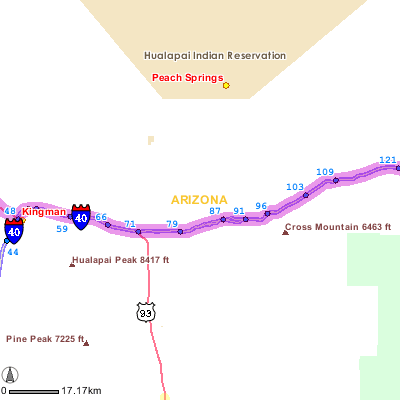
| 62. | NM-170 becomes CO-140. Drive for 37.3 kilometers. |
| 63. | Turn LEFT to get on US-160 heading NORTHWEST. Drive for 55 kilometers. |
| 64. | Turn SLIGHT RIGHT onto PINON DRIVE N. Drive for 500 meters. |
| 65. | Go STRAIGHT on US-491 N. Drive for 95.9 kilometers. |
| 66. | Turn RIGHT onto N MAIN STREET. Drive for 2.2 kilometers. |
| 67. | N MAIN STREET becomes US-191. Drive for 83.9 kilometers. |
| 68. | Turn LEFT onto W 200 S. Drive for 200 meters. |
| 69. | You have reached the stop-over. |
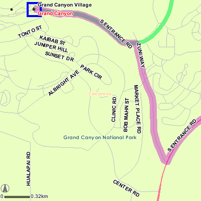
Moab, Utah to Grand Canyon Village, Arizona
Distance: 526.6km (327.2 miles)
|
| 70. | Start out heading EAST on W 200 S towards S 100 W. Drive for 200 meters. |
| 71. | Turn RIGHT onto S MAIN STREET. Drive for 1.3 kilometers. |
| 72. | Go STRAIGHT on S US-191. Drive for 208.1 kilometers. |
| 73. | Keep RIGHT to stay on S US-191. Drive for 3.7 kilometers. |
| 74. | S US-191 becomes US-160. Drive for 198 kilometers. |
| 75. | Turn LEFT onto US-89. Drive for 25.1 kilometers. |
| 76. | Turn RIGHT onto AZ-64. Drive for 84.8 kilometers. |
| 77. | Turn LEFT onto S ENTRANCE ROAD. Drive for 1.8 kilometers. |
| 78. | Turn RIGHT onto an access street. Drive for 900 meters. |
| 79. | Keep RIGHT to stay on an access street. Drive for a short distance. |
| 80. | Go STRAIGHT on ZUNI WAY. Drive for 400 meters. |
| 81. | Turn LEFT onto S ENTRANCE ROAD. Drive for 1.1 kilometers. |
| 82. | Go STRAIGHT on VILLAGE LOOP ROAD. Drive for a short distance. |
| 83. | You have reached the stop-over. |
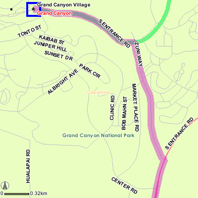
Grand Canyon Village, Arizona to Las Vegas, Nevada
Distance: 444.5km (276.2 miles)
|
| 84. | Start out heading EAST on VILLAGE LOOP ROAD towards S ENTRANCE ROAD. Drive for a short distance. |
| 85. | Go STRAIGHT on S ENTRANCE ROAD. Drive for 1.1 kilometers. |
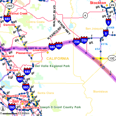
| 86. | Turn RIGHT onto ZUNI WAY. Drive for 400 meters. |
| 87. | Go STRAIGHT on an access street. Drive for a short distance. |
| 88. | Keep LEFT to stay on an access street. Drive for 900 meters. |
| 89. | Turn RIGHT onto S ENTRANCE ROAD. Drive for 2.4 kilometers. |
| 90. | S ENTRANCE ROAD becomes US-180. Drive for 41 kilometers. |
| 91. | Go STRAIGHT on AZ-64. Drive for 44.6 kilometers. |
| 92. | Turn RIGHT to get on I-40 W towards I-40 W / AZ-89 S. Drive for 186.1 kilometers. |
| 93. | Take exit number 48 towards BEALE ST / US-93 / LAS VEGAS / AZ-66 / AZ-68. Drive for 500 meters. |
| 94. | Turn RIGHT onto W BEALE STREET. Drive for 1000 meters. |
| 95. | W BEALE STREET becomes US-93. Drive for 124.8 kilometers. |
| 96. | Go STRAIGHT on NEVADA HIGHWAY. Drive for 1.3 kilometers. |
| 97. | Go STRAIGHT to get on NEVADA HIGHWAY heading WEST. Drive for 3.3 kilometers. |
| 98. | NEVADA HIGHWAY becomes US-93 N. Drive for 34.9 kilometers. |
| 99. | Take exit number 75 towards LAS VEGAS BLVD / DOWNTOWN LV. Drive for 500 meters. |
| 100. | Turn LEFT onto N LAS VEGAS BOULEVARD. Drive for 300 meters. |
| 101. | Turn RIGHT onto STEWART AVENUE. Drive for a short distance. |
| 102. | You have reached the stop-over. |
Las Vegas, Nevada to San Francisco, California
Distance: 916.8km (569.7 miles)
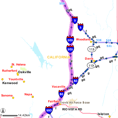
|
| 103. | Start out heading NORTHWEST on STEWART AVENUE towards N 4TH STREET. Drive for a short distance. |
| 104. | Turn RIGHT onto N 4TH STREET. Drive for 300 meters. |
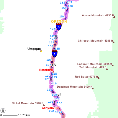
| 105. | Turn SLIGHT LEFT to get on I-515 N towards US-93 N / US-95 N / I-15. Drive for 500 meters. |
| 106. | Take exit number 76A to get on I-15 S towards LOS ANGELES. Drive for 254.7 kilometers. |
| 107. | Take CA-58 W towards CA-58 / BAKERSFIELD. Drive for 201.1 kilometers. |
| 108. | Take CA-99 N towards CA-58 W / CA-99 N / SACRAMENTO. Drive for 33.3 kilometers. |
| 109. | Take CA-46 towards WASCO / PASO ROBLES. Drive for 40.7 kilometers. |
| 110. | Turn RIGHT to get on I-5 N. Drive for 269.8 kilometers. |
| 111. | Keep SLIGHT LEFT at the fork towards I-580 W. Drive for 99.2 kilometers. |
| 112. | Take I-80 W towards SAN FRANCISCO. Drive for 12.4 kilometers. |
| 113. | Take exit towards CIVIC CENTER / NINTH STREET. Drive for 300 meters. |
| 114. | Turn SLIGHT LEFT onto HARRISON STREET. Drive for 200 meters. |
| 115. | Turn RIGHT onto 9TH STREET. Drive for 700 meters. |
| 116. | Go STRAIGHT on HAYES STREET. Drive for 300 meters. |
| 117. | Turn RIGHT onto VAN NESS AVENUE. Drive for 200 meters. |
| 118. | You have reached the stop-over. |
San Francisco, California to Victoria, British Columbia
Distance: 1441.8km (895.9 miles)
|
| 119. | Start out heading NORTH on VAN NESS AVENUE towards MCALLISTER STREET. Drive for 600 meters. |
| 120. | Turn RIGHT onto OFARRELL STREET. Drive for 1.3 kilometers. |
| 121. | Turn RIGHT onto STOCKTON STREET. Drive for 100 meters. |
| 122. | Turn SLIGHT RIGHT onto 4TH STREET. Drive for 900 meters. |
| 123. | Turn LEFT onto BRYANT STREET. Drive for 600 meters. |
| 124. | Turn LEFT to get on I-80 E. Drive for 84.9 kilometers. |
| 125. | Take I-505 N towards WINTERS / REDDING. Drive for 54.9 kilometers. |
| 126. | Go STRAIGHT on I-5 N. Drive for 851.7 kilometers. |
| 127. | Take exit number 288 to get on I-205 N towards I-205 / THE DALLES / I-84 / SEATTLE. Drive for 58.1 kilometers. |
| 128. | Take I-5 N. Drive for 154.8 kilometers. |
| 129. | Take exit number 104 to get on US-101 N towards ABERDEEN / PORT ANGELES. Drive for 177.1 kilometers. |
| 130. | US-101 N becomes US-101 S. Drive for 10.9 kilometers. |
| 131. | Go STRAIGHT on E FRONT STREET. Drive for 200 meters. |
| 132. | Turn RIGHT onto N LAUREL STREET. Drive for 200 meters. |
| 133. | Take the PORT ANGELES-VICTORIA BC FERRY for 16.4 kilometers. |
| 134. | You are leaving the United States and entering Canada. |
| 135. | Go STRAIGHT on VICTORIA-PORT ANGELES FERRY. Drive for 20.1 kilometers. |
| 136. | Go STRAIGHT on an access street. Drive for a short distance. |
| 137. | Turn LEFT onto BELLEVILLE STREET. Drive for 700 meters. |
| 138. | Turn LEFT onto DOUGLAS STREET. Drive for 900 meters. |
| 139. | You have reached the destination. |
 TripTikÆ